
Sweetwater Creek Lower Nature Reserve Boardwalk
ID: 5af9242ee151d75f5fe48501Frankston South, Frankston South, Victoria
Frankston South,
Frankston South,
Victoria
3199.
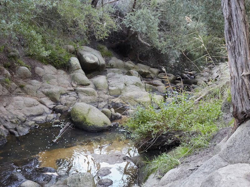
Sweetwater Creek extends from the foothills of Frankston Reservoir to Port Philip Bay at the base of Olivers Hill. Thirteen hectares of remnant bushland surrounding the lower section of the creek is protected for its flora, fauna, geological and cultural heritage values. Walking tracks wind their way along the creek from swamps to steep gullies and floodplains to foothills. The Reserve corridor remains a unique ribbon of forest, heath, swamp and grassland interlocked by walking trails and resting places. After 200 metres or so after the Liddesdale entrance, the walking track winds through the bush habitat by a series of steps and inclines to areas of heath and grasses. The main track takes walkers beside rock pools, across bridges, through an enclosure of native shrubbery and eventually onto a boardwalk. “The Granites” is a particularly beautiful spot where the creek has carved out its path around large rocky outcrops and boulders. The boardwalk now winds through a corridor of melaleuca and swampland. Narringalling, meaning ‘sweet water’, is the name given to the creek by the local Boon Wurrung people who used it as a source of freshwater. Around the 1850s European settlers built huts near the creek mouth. In the late 1800s logging by woodcutters operating out of Canadian Bay resulted in the clearing of most of the eucalypts and wattles. The timber was used for the Melbourne fuel, furniture and tanning markets. The denuded areas were then invaded by Coast Tea-tree. The reserve has been rehabilitated and the creek has again become an excellent habitat for indigenous plants and animals. The trail commences opposite 1A Liddesdale Avenue....
Product Types
- Trails
Activities you can engage in
- Walks
Itineraries
Sweetwater Creek Lower Nature Reserve Boardwalk
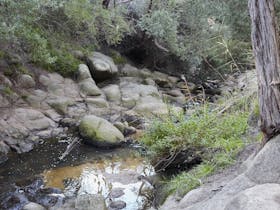
Sweetwater Creek extends from the foothills of Frankston Reservoir to Port Philip Bay at the base of Olivers Hill. Thirteen hectares of remnant bushland surrounding the lower section of the creek is protected for its flora, fauna, geological and cultural heritage values. Walking tracks wind their way along the creek from swamps to steep gullies and floodplains to foothills. The Reserve corridor remains a unique ribbon of forest, heath, swamp and grassland interlocked by walking trails and resting places. After 200 metres or so after the Liddesdale entrance, the walking track winds through the bush habitat by a series of steps and inclines to areas of heath and grasses. The main track takes walkers beside rock pools, across bridges, through an enclosure of native shrubbery and eventually onto a boardwalk. “The Granites” is a particularly beautiful spot where the creek has carved out its path around large rocky outcrops and boulders. The boardwalk now winds through a corridor of melaleuca and swampland. Narringalling, meaning ‘sweet water’, is the name given to the creek by the local Boon Wurrung people who used it as a source of freshwater. Around the 1850s European settlers built huts near the creek mouth. In the late 1800s logging by woodcutters operating out of Canadian Bay resulted in the clearing of most of the eucalypts and wattles. The timber was used for the Melbourne fuel, furniture and tanning markets. The denuded areas were then invaded by Coast Tea-tree. The reserve has been rehabilitated and the creek has again become an excellent habitat for indigenous plants and animals. The trail commences opposite 1A Liddesdale Avenue.
Facilities found here
- Carpark
Travel Method
- Walk
Route Type
- Return over same path
Difficulty
- Grade 2
Back To Search